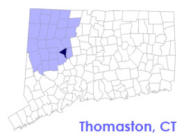
Thomaston Connecticut 06778
Thomaston CT Town Travel Business Information
 Welcome to scenic Thomaston, Connecticut.
Thomaston, originally part of Plymouth, Connecticut, and referred to as ‘Plymouth Hollow’, was first settled in the early 1700s. It was incorporated in its own right and under the name ‘Thomaston’ in 1875.
The name derives from Seth Thomas, the early clockmaker, who established a factory in town. The Seth Thomas clock factory building still exists, however, the clock-making industry has long since left the state and eventually the country. The Thomaston Dam Project has created a large watershed area visible from Route 222. The Thomaston Dam is across the Naugatuck River.
To share any Thomaston, CT information with us, please contact us.
Thomaston Connecticut Town Guide

Incorporated: 1875
County: Litchfield
Thomaston, CT Population:
2005: 7,938
GPS Coordinates:
Latitude: 41.4015
Longitude: -73.0457
Thomaston CT Local Information
Thomaston Police Dispatch: 860-283-4343
Thomaston Fire Department: 860-283-4344
Ambulance Service: 911
Town Hall Telephone: 860-283-4141
Shop 24/7 at FREE WORLD MALL
inns | hotels | resorts | rentals | attractions | dining | real estate
SUGGESTED LITCHFIELD VALLEY CT LODGING Visit Litchfield CT Vacation Specials. Browse current Litchfield CT area vacation rentals, inns, resorts, and pet-friendly lodging availabilities below.Connecticut Town & City Guides by Region
Vacation Rentals | Pet Friendly
Attractions | Maps | Products
Free World Mall
Country Weddings | New England Recipes
Paradise Coast Living | Boston Red Sox Gifts


